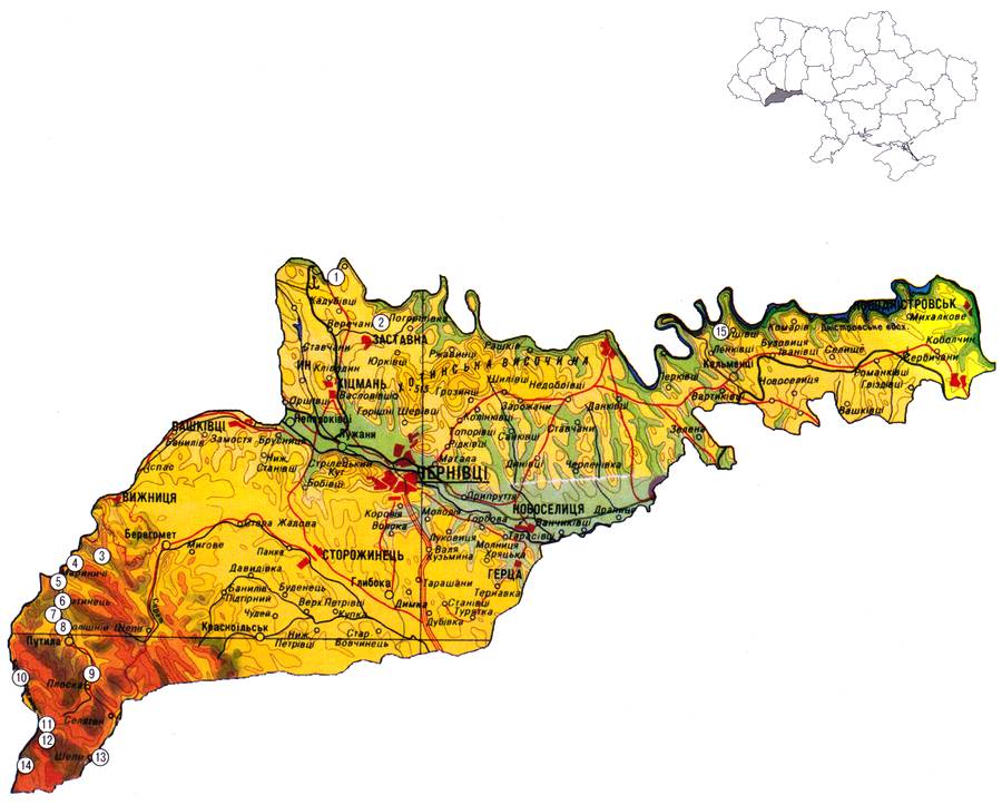
GEOLOGICAL LANDMARKS OF UKRAINE. CHERNIVTSI REGION.
North-eastern part of Chernivtsi Region includes fragments of the Eastern-European Platform margin structures, the central part — Fore-Carpathian Trough, and south-western part — the External Carpathians.
Archean and Early Proterozoic mafic gneisses and granitoids which constitute platform basement up to 1.5-4.5 km depth are overlain by sedimentary cover of Vendian, Paleozoic (Cambrian — Lower Devonian), Mesozoic (Upper Jurassic, Cretaceous), and Cenozoic (Neogene). They form specific structure levels separated by basal horizons — Dnistrovska peri-cratonic monocline, Boyanetskiy Trough, Stryiskiy Jurassic Trough, and Cenozoic structure level composed of thin carbonate-terrigenous sequence which is almost horizontal-laying and is overlain by the cover of sub-aqual (alluvial), sub-aerial (aeolian-delluvial, elluvial) and intermediate (delluvial-colluvial, elluvial-delluvial, delluvial-slided) rocks of PlioceneQuaternary age. External part of Fore-Carpathian Trough — Bilche-Volytska Zone represents platform margin buried along the system of northwest strike normal faults. This zone is filled up with thick (up to 1.6 km) Upper Miocene molassa which is gently sloping toward Carpathians. From the west Bilche-Volytska Zone is surrounded by Carpathian Mega-Thrust.
Within Mega-Thrust in the Region territory there are traced only structures of the External Carpathians and internal part of the Fore-Carpathian througt. In the External Carpathians from north-west to south-east there are distinguished Marmaroshskiy Massif composed of mainly metamorphic schists and terrigenous-carbonate rocks of Paleozoic age, Rakhivskiy and Chornogorskiy Thrusts, Krosnenska Zone, and Skyboviy Thrust composed of highly-deformed Cretaceous — Lower Miocene flysch rocks of more than three thousand meters total thickness. Northeastward Skyboviy Nappe is over-thrusted onto the internal part of the Trough along about 50 km.
From the two thrust counterparts of the trough’s internal part in the Region predominate Boryslav-Pokutskiy nappe which almost completely overlies Sambirskiy Nappe. Anticline structures of the former one form low-hill ridges in the relief which clearly coincides with the rock strike. Anticlines are asymmetric with overturned northeastern limbs. To the south-east they gradually transform into the nappes. Structures of Boryslav-Pokutskiy thrust are mainly composed of Upper Cretaceous — Lower Miocene flysch rocks and partly of Lower Miocene molassa
Sambirskiy Thrust is traced in the Region as narrow nappe composed of parti-colored, saltbearing and olistostrome Miocene rocks. To the north-east this nappe is over-thrusted onto the external part of the trough along significant distance.
Medium-hill relief of the south-eastern part of Region is defined by massifs of Chyvchynski and Grynyavski Mountains. Putylske lowland with flat watersheds represents relics of the ancient Pliocene lengthwise Carpathian hydro-system. Mediumand lowland Pokutsko-Bukovynski Carpathians (from 800 1000 m to 1100-1350 m) which occupy almost quarter of the Region territory are flat-hill and steep-hill ridges of northeast strike. Between Carpathian boundary and Prut River valley there extends Fore-Carpathian Height (up to 50 m high) which is extensively broken into single hill massifs with flay watersheds formed by relicts of Pliocene terraces of Cheremosh River. There on steep slopes there runs active slides development The country between Prut and Dnister Rivers in the north of Region coincides with the margin of Podilska Height (up to 300 m high) and Khotynska Height with the highest point of the plain Ukraine Berda Mountain (515 m). Khotynska Height represents an eleva ted plain broken by terraced water-stream valleys into separated ridge-hill parcels.
Sourсe: Geological Landmarks of Ukraine: In 3 volumes/V.P. Bezvynniy, S.V. Biletski, O.B. Bobrovetal.; V.L. Kalinin, D.S. Gurskiy, I.V. Antakova, Eds. — K.: DIA, 2006. — Volume I.

Comment